| Location: | Ichetucknee Springs State Park, Columbia County, Florida |
|---|---|
| Occupation Dates: | 1608 to 1657 (as mission site); earliest date of pre-Spanish Timucua settlement unknown |
| Excavator(s): | John Goggin (surface collections); Kenneth Johnson; Brent Weisman; John Worth |
| Dates excavated: | 1986 (Johnson); 1988-1989 (Weisman); 1990 (Worth) |
Overview
The Fig Springs site (state site number 8Co1) is home to what is believed to be the mission San Martín de Timucua. Located in Ichetucknee Springs State Park, the site is situated on a terrace approximately 8 meters above the springs and along the shoreline of the Ichetucknee River. The mission was established in 1608 during fray Martín de Prieto’s evangelizing enterprise in the Florida interior. It was placed in the head village of a Timucua chiefdom whose chief oversaw a number of subordinate villages that also came to house doctrinas and visitas. According to his account, fray Martín infamously burned 12 wooden images in the village plaza.
There are few historical descriptions of the mission following its founding. Notably, the indigenous community may have played a key role in instigating the 1656 Timucua uprising. San Martín de Timucua appears to have been destroyed in 1657 during the rebellion and it does not appear on subsequent mission lists.
Throughout the twentieth century Fig Springs was a popular source of both Native American and European artifacts for collectors. As a result, John Goggin made numerous visits there in 1949 and the 1950s to collect what he considered to be a distinctive array of Spanish majolica sherd types. However, he did not locate the site itself. That credit goes to University of Florida archaeologist Kenneth Johnson (working under the supervision of Jerald Milanich) who investigated the area in 1986-1987 as part of a state park initiative to recognize Florida’s Spanish heritage (Johnson 1987, 1990).
Johnson’s preliminary shovel-test investigations identified seventeenth-century Spanish artifacts, human burials, and a patch of possible burned clay floor. His work was followed by 16 months of fieldwork by Brent Weisman, beginning in 1988. That research, which led to a published book (Weisman 1992), identified the mission church, the convento, the mission cemetery, and a large native structure in the village. No work has been conducted at Fig Springs since that time.
In 1990, John Worth conducted the last systematic investigations at Fig Springs. His work focused on the southernmost portion of the site, which contained cultural deposits related to the pre-mission period. Worth’s goal was to develop a regional cultural and ceramic sequence of the so-called Suwannee Valley complex that characterized the Timucua peoples prior to European contact.
Documentary Evidence
Like other missions in the Florida interior, the first published description of San Martín de Timucua is attributed to the testimonial of fray Martín Prieto as collected by fray Luís Jerónimo de Oré. Oré visited the colony of Florida on two occasions in order to investigate the organization of the missions and their success in converting Native Americans. His first visit in 1614 was in the capacity of Commissary General of the Indies. Individuals holding this position represented the Franciscan Order in New Spain and Central America and reported to the Minister General in Rome. After leaving this office and following a brief posting in Spain, Oré returned to Florida in 1616 in the role of visitor general. Oré summarized his investigations in the book Martyrs of Florida (Oré 1936). This work is recognized as a key primary source for the first Franciscan missions in the region.
The brief account of the founding of San Martín de Timucua comes in the form of a first-hand declaration made by fray Prieto to fray Oré. Prieto related that the cacique of the district of Timucua was renowned throughout Florida for his power and that he had more than twenty settlements under his command. After nearly three years of attempting to convert the cacique, the chief went to St. Augustine in 1607 to adopt Catholicism and to ask the governor to Christianize his province. Prieto followed in 1608 to found a mission in the main town of the province, which he dubbed San Martín.
There are a number of first-hand descriptions of the various missions in interior Florida throughout the seventeenth century, typically from the accounts of church officials or from periodic “visitations” throughout the colony made by colonial delegates, such as governors. For missions among the Timucua Indians, these are best summarized by the discussions and references to be found in the volumes by John Worth (1998a, 1998b) and John Hann (1996). The book, The Cross in the Sand by Michael Gannon (1965), which addresses the history of the Catholic Church in Florida, is an important contextual study.
Excavation History, Procedure, and Methods
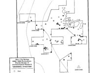
Kenneth Johnson (1987) investigated the Fig Springs site between December 10, 1986, and January 17, 1987, as part of a larger survey of Spanish colonial sites in northern peninsular Florida. His work consisted of the placement of 44 shovel test pit (STP) units at 30 m intervals. Many of these were excavated along an east-west axis that cross-cut the bank of the springs, the adjoining slope, and bluff top. He placed a second line of STPs perpendicular to this axis and parallel to the bluff edge. STPs were about 50 x 50 cm in area and generally 60 to 85 cm deep. They were excavated by arbitrary 10 cm levels within natural strata and screened through one-quarter inch mesh. Artifacts from each level were bagged separately.
A metal detector survey was also conducted over a 20 x 90 meter area. This work identified five clusters (labeled A through E) of likely Spanish metal objects, primarily wrought-iron nails.
Two burials were identified and partially uncovered, but the bones were not removed from the field. One consisted of an extended adult and a child, the other an extended adult. No burial goods were identified, but Weisman’s later excavations (described below) identified the burials as belonging to a mission cemetery.
In locations yielding artifacts or features of interest, Johnson excavated additional STPs as well as formal test units. Two 1 x 2 meter test units were excavated, in addition to one 1 x 1 meter unit. Soils from the test units were screened through one-quarter inch mesh. In addition, he placed several dozen small-diameter soil probe cores to follow the extent of a clay floor located in the STP survey. The relative shallowness of the clay floor at 20-23 cm below ground surface and its relatively intact nature (confirmed in later excavations), suggested that this area of the site had not been plowed.
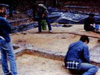
Under Weisman’s direction, fieldwork the following year took place over three phases. The first phase, from February 1 to May 10, 1988, consisted of the excavation of 208 auger borings placed at 10 meter intervals. This work recovered 123 field specimens and delineated the site boundaries, as well as a number of internal features including two to three mission structures and a midden area related to the native village. Based on this work, the size of the mission complex was estimated at 3500 square meters and the size of the native village was estimated at 4 hectares.
The second phase of excavations was conducted from July 7 to October 25 of 1988 with the goal of more fully investigating the sub-surface features assumed to represent the mission complex. Because of concerns that the auger boring interval was too coarse to identify the extent and exact nature of features, phase two began with the retrieval of soil cores at one-meter intervals at locations judged likely to contain architectural remains. Samples were taken with a 20-mm stainless steel hand corer. Formal excavation units were then placed at points where the soil cores yielded evidence of possible architectural remains, such as burnt clay, clay rubble, and carbonized wood. A metal detector survey was also conducted in select areas of the site.
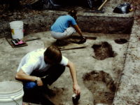
A total of 26 2 x 2 meter units were completely or partially excavated, comprising 104 square meters of excavated area. General excavation fill was screened through one-quarter inch mesh. Soil was excavated in both natural and cultural layers.
Archaeologists mapped in situ artifacts that were believed to be on occupation surfaces. Features were drawn in plan view before excavation. Feature fill was water screened in the field through 1/16-inch mesh or else bagged for flotation.
Fill from the burials was excavated and separately screened. Fill located directly around the skeleton was water screened using 1/16-inch mesh. All burials were measured, drawn, and photographed in place.
The third phase of Weisman’s excavations, from January 9 to October 2, 1989, focused on targeted expansion and additional testing of the church, convento, and indigenous structure. Additional testing was conducted in the village area where several more middens and another indigenous structure were found.
John Worth’s 1990 investigations focused on the south end village. He placed a 136 square meter block excavation immediately to the south of the southernmost occurrence of mission-period artifacts. This work revealed a number of pit features and a large charred post (likely a center post for a structure) that was radiocarbon dated to AD 1160 +/- 50.
Summary of Research and Analysis
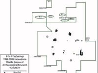
Weisman’s excavations revealed three mission-era buildings, which were partially excavated. Basing his analysis on Jones and Shapiro’s mission model (1990), Weisman interprets these structures as a church, convento, and a large native domicile.
The church, estimated at 10.5 meters N-S and 8.5 meters E-W, was characterized by the remnants of a prepared floor and evidence for hewn posts and pine sills. It had three internal rooms.
The convento was identified by the remains of a charred, hewn post and a concentration of wrought-iron nails, in addition to other Spanish artifacts.
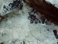
A portion of a single-post Indigenous structure was excavated, with an estimated floor area of 9 meters (N-S) by 14 m (E-W). It is rectangular with rounded corners. Interior posts along the walls are suggestive of sleeping benches, and these were underlain by smudge pits filled with carbonized corn cobs and wood fragments. The interior space contained several hearths. Seventy-eight pit features of varying dimensions appear to be related to this structure. One corn-cob filled pit yielded a radiocarbon date of 1590 + 60. This building was located on the south side of the site and was surrounded by evidence for extensive Native American remains. For this reason, Weisman referred to this portion of the site as the “south end village.”
A mission cemetery that presumably served Christian natives was discovered next to the north wall of the church. It was partially excavated. Although Weisman only identified and removed eleven burials, he estimates that upwards of 400 individuals may have been buried there.
Based on his investigations, Weisman (1992) posited that several other features of the mission and village had been identified. These include a plaza between the mission complex and the village area, possibly the mission kitchen (cocina), and two foot trails (likely contemporary with the mission and village) to the springs, one leading from the convento and one from the village area.
The architectural interpretations made by Weisman are not universally accepted. In another interpretation, Rebecca Saunders (1996) has hypothesized that his convento was actually a secondary church.
John Worth’s work, complemented by testing at nearby sites, allowed him to develop a more fine-grained ceramic sequence for his Suwanne Valley series for the pre-mission Timucua. Importantly, he observed that the Jefferson series ceramics found at Fig Springs, which appear to have Lamar affiliations, have no local precedent in the region. As a result, he hypothesized that they were associated with groups from the Apalachee region who had joined the mission at Fig Springs.
Gifford Waters and Charles Cobb
Florida Museum of Natural History
University of Florida, Gainesville, FL
August 2019
Site Grid
All horizontal and vertical measurements are on the metric scale. A permanent grid system was established by Weisman before his three-phase study. A datum was established near the clay floor found by Kenneth Johnson and arbitrarily designated 300N/300E.
Stratigraphy
The following nomenclature was assigned to the soil horizons:
Zone 1, Level 1: the recent humus horizon. This ranged from 5 to 12 cm thick.
Zone 1, Level 2: this referred to an older, thin lens of humus and gray sand that could be found at some locations under the more recent humus.
Zone 2, Level 1: a layer of grey, brown, or tan sand below Zone 1. This was excavated in 10 cm arbitrary levels, with each level receiving a numerical designation (e.g., Zone 2, Level 1, Zone 2, Level 2, etc.).
Zone 3: culturally sterile sands and clays.
Most of the artifacts were recovered from Levels 1 and 2 in Zone 2.
Nomenclature
• Metal detector finds were recorded with the prefix MD.
• field specimen (FS) numbers were assigned to artifacts.
• Individually mapped artifacts were provided and given a map specimen (MS) number in addition to a FS number.
• Features were assigned numbers.
• Post molds and post holes were assigned numbers separately from features during the 1988 phase two investigations, but were assigned feature numbers during the 1989 phase three investigations.
Records
All excavations were recorded using a standard form. Other records include: daily journals, plan view and profile maps of all units, field specimen, map specimen and soil sample logs, Polaroid prints, color slides, and black-and-white prints of the excavations.
Note: some posts received feature designations, whereas others were assigned post hole (PH) or post mold (PM) numbers.
| Features Associated with the Church | |||||||||||
| Feature | Feature Type | Unit Corner | |||||||||
| F1 | Stain | 299N 314E | |||||||||
| F2 | Prepared Floor | 299N 314E | |||||||||
| F3a | Possible Post | 295N 314E | |||||||||
| F3b | Double Post | 295N 314E | |||||||||
| F21 | Possible Post Hole | 301N 314E | |||||||||
| F23 | Burned Post | 297N 312E | |||||||||
| F24 | Determined not a feature | 303N 316E | |||||||||
| F25 | Square Post | 299N 312E | |||||||||
| F26 | Charred Post | 295N 312E | |||||||||
| F27 | Multiple Post Remains | 297N 312E | |||||||||
| F28 | Possible Post | 299N 312E | |||||||||
| F36 | Possible Burial Pit | 303N 316E | |||||||||
| F40 | Burial Pit Fill | 306N 310E | |||||||||
| Other Features | |||||||||||
| Feature | Feature Type | Unit Corner | |||||||||
| F7 | Pit | 242N 287E | |||||||||
| F8 | Possible Hearth | 240N 295E | |||||||||
| F9 | Pit/Intrusion | 242N 287E | |||||||||
| F10 | Deposit of Hearth Fill | 244N 295E | |||||||||
| F11 | Charred Cob/Smudge Pit | 240N 295E | |||||||||
| F12 | Charred Cob/Smudge Pit | 240N 295E | |||||||||
| F13 | Charred Cob/Smudge Pit | 240N 295E | |||||||||
| F14 | Charred Cob/Smudge Pit | 240N 295E | |||||||||
| F15a | Dog Burial | 238N 240E & 297N 295E | |||||||||
| F15b | Dog Burial | 240N 295E | |||||||||
| F16 | Storage/Refuse Pit | 240N 295E | |||||||||
| F17 | Possible Post Mold | 240N 295E | |||||||||
| F20 | Fire Pit | 240N 295E | |||||||||
| F30 | Post | 238N 297E | |||||||||
| F31 | Possible Pit | 238N 297E | |||||||||
| F32 | Pit | 238N 297E | |||||||||
| F33 | Trash Pit | 238N 297E | |||||||||
| F34 | Post | 322N 300E | |||||||||
| F37 | Post Hole Fill | 238N 297E | |||||||||
| F38 | Possible Post Hole Fill | 238N 297E | |||||||||
| F41 | Post Hole Fill | 238N 297E | |||||||||
| F42 | Trash Pit | 238N 297E | |||||||||
| F43 | Pit | 238N 297E | |||||||||
| F44 | Post Trench | 236N 298E | |||||||||
| F45 | Smudge Pit | 236N 298E | |||||||||
| F46 | Smudge and/or Post Pit | 236N 298E | |||||||||
| F47 | Post E1/2 and Pit W1/2 | 236N 298E | |||||||||
| F48 | Charred Cob/Smudge Pit | 236N 298E | |||||||||
| F49 | Charred Cob/Smudge Pit | 240N 289E | |||||||||
| F50 | Possible Charred Cob/Smudge Pit | 240N 289E | |||||||||
| F51 | Unidentified Intrusion | 240N 289E | |||||||||
| F52 | Stain | 242N 292E | |||||||||
| F53 | Stain | 242N 292E | |||||||||
| F54 | Stain | 242N 292E | |||||||||
| F56 | Pit | 240N 289E | |||||||||
| F57 | Pit | 242N 292E | |||||||||
| F58 | Pit | 242N 292E | |||||||||
| F59 | Charred Cob/Smudge Pit | 238N 297E | |||||||||
| F60 | Pit | 242N 295E | |||||||||
| F60 (2) | Possible Roasting Pit | 242N 295E | |||||||||
| F61 | Possible Post | 238N 297E | |||||||||
| F63 | Pit | 238N 297E | |||||||||
| F64 | Possible Post | 238N 297E | |||||||||
| F65 | Trash Pit/ Pit Fill | 238N 297E | |||||||||
| F68 | Possible Charred Post | 242N 295E | |||||||||
| F69 | Possible Post | 236N 298E | |||||||||
| F70 | Trash Pit | 236N 298E | |||||||||
| F71 | Hearth/Fire Pit | 236N 293E | |||||||||
| F72 | Hearth/Fire Pit | 236N 293E | |||||||||
| F73 | Pit | 232N 295E | |||||||||
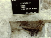
| F74 | Possible Hearth/Fire Pit | 236N 293E | |||||||||
| F75 | Root Intrusion | 236N 293E | |||||||||
| F76 | Hearth/Fire Pit | 236N 293E | |||||||||
| F77 | Charred Cob/Smudge Pit | 232N 295E | |||||||||
| F78 | Possible Smudge Pit | 236N 288E | |||||||||
| F79 | Possible Post | 236N 288E | |||||||||
| F81 | Stain | 229N 295E | |||||||||
| F82 | Charred Cob/Smudge Pit | 240N 289E | |||||||||
| F83 | Possible Smudge/Hearth | 232N 295E | |||||||||
| F88 | Unidentified Pit | 240N 289E | |||||||||
| F90 | Pit | 50N 295E | |||||||||
| F91 | Possible Pit | 242N 292E | |||||||||
| F92 | Pit | 236N 298E | |||||||||
| F94 | Hearth/Fire Pit | 236N 293E | |||||||||
| F95 | Charred Cob/Smudge Pit | 234N 291E | |||||||||
| F96 | Possibble Pit | 236N 288E | |||||||||
| F98 | Pit | 234N 291E | |||||||||
| F101 | Pit | 236N 298E | |||||||||
| F102 | Pit | 236N 298E | |||||||||
| F103 | 2 Pits | 238N 297E | |||||||||
| F109 | Fire Pit | 236N 297E | |||||||||
| F110 | Possible Smudge Pit | 236N 288E | |||||||||
| F111 | Charred Cob/Smudge Pit | 236N 288E | |||||||||
| F112 | Possible Smudge Pits | 236N 298E | |||||||||
| F113 | Post Pit | 51N 297E | |||||||||
| F114 | Post Pit | 51N 297E | |||||||||
| F120 | Possible Hearth | 53N 304E | |||||||||
| F121 | Charcoal Concenration | 53N 301E | |||||||||
| F122 | Pit | 48N 299E | |||||||||
| F132 | Unidentified Pit | 49N 309E | |||||||||
| F135 | Clay Lined Pit | 118N 229E | |||||||||
| F136 | Pit | 118N 229E | |||||||||
| Non-Cultural Features | |||||||||||
| Feature | Feature Type | Unit Corner | |||||||||
| F4 | Possible Tree Fall | 295N 322E | |||||||||
| F5 | Prehistoric Stump | 310N 370E | |||||||||
| F6 | Charred Root | 302N 375E | |||||||||
| F18 | Possible Root | 240N 295E | |||||||||
| F29 | Root Disturbance | 256N 306E | |||||||||
| F39 | Tree Distrubance | 295N 318E | |||||||||
| F87 | Unidentified Intrusion | 242N 292E | |||||||||
| F134 | Not Specified | 118N 229E | |||||||||
| F141 | Not Specified | 49N 302E | |||||||||
| F142 | Not Specified | 49N 302E | |||||||||
| Unknown Features | |||||||||||
| F19, 22,35,55,62,66,67,80,84-86,89,93,97,99,100,104-108,115-119,123-131,133,137-140 | |||||||||||
| Post Holes and Molds | |||||||||||
| Post Hole | Unit Corner | ||||||||||
| PH1 | 229N 312E | ||||||||||
| PH2 | 320N 312E | ||||||||||
| PH3 | 320N 280E | ||||||||||
| PH5 | 297N 312E | ||||||||||
| PH5 | 325N 312E | ||||||||||
| Post Mold | |||||||||||
| PM2 | 320N 280E | ||||||||||
| PM3 | 323N 285E | ||||||||||
| PM8 | 242N 287E | ||||||||||
| PM8 | 325N 296E | ||||||||||
| PM9 | 301N 314E | ||||||||||
Shapefile of site plan, compressed as zipfile.
